File:Hinterlands leads.png
From Fallen London Wiki
Size of this preview: 338 × 599 pixels. Other resolutions: 135 × 240 pixels | 453 × 803 pixels.
Original file (453 × 803 pixels, file size: 57 KB, MIME type: image/png)
Summary[edit]
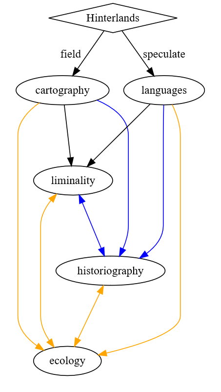
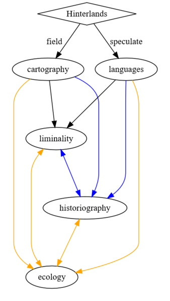
A graph of how the leads work for the Hinterlands Jericho library research project. Generated with this DOT code:
digraph G {
subgraph clusterleads{
   style=invis;
   cartography -> liminality;
   languages -> liminality;
   liminality -> historiography [color=blue][dir=both];
   cartography -> historiography [color=blue];
   languages -> historiography [color=blue];
   cartography -> ecology [color=orange];
   liminality -> ecology [color=orange][dir=both];
   historiography -> ecology [color=orange][dir=both];
   languages -> ecology [color=orange];
 }
 Hinterlands [shape=diamond];
 Hinterlands -> cartography [
       taillabel="field"
       labeldistance=5.0
       labelangle=340
      ];
 Hinterlands -> languages [label=speculate]
}
Licensing[edit]
This file was uploaded by the photographer or author.
File history
Click on a date/time to view the file as it appeared at that time.
| Date/Time | Thumbnail | Dimensions | User | Comment | |
|---|---|---|---|---|---|
| current | 17:35, 26 May 2024 | | 453 × 803 (57 KB) | OuroborusInc (talk | contribs) | A graph of how the leads work for the Hinterlands Jericho library research project. Generated with this DOT code: digraph G { subgraph clusterleads{ style=invis; cartography -> liminality; languages -> liminality; liminality -> historiography [color=blue][dir=both]; cartography -> historiography [color=blue]; languages -> historiography [color=blue]; cartography -> ecology [color=orange]; liminality -> ecology [color=orange][dir=both]; historiography -> e... |
You cannot overwrite this file.
File usage
The following page uses this file: